Showing posts with label Cucuron. Show all posts

Saturday, March 14, 2020

Cucuron: Autour de Cucuron et la Boissiere.

Cucuron.

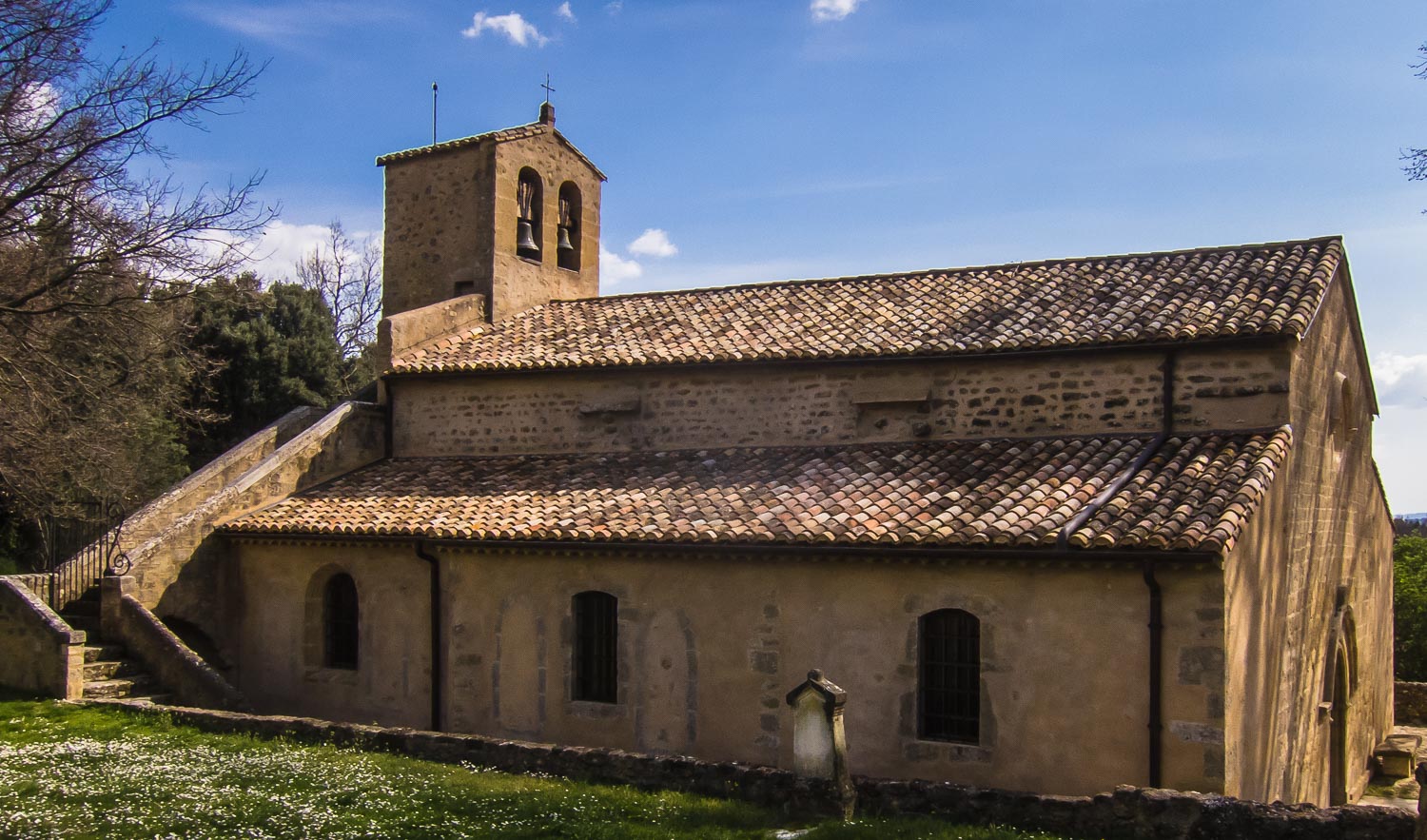
This is a local walk around Cucuron, starting with Chapelle de l’Hermitage with great views. Afterwards the walks go eastwards on the GR9 trail in direction of Cabrieres d’Aigues, but you take off this trail down passed the old ruins of la Reynaude. You continue further down south passed la Boissieres and finally arriving at Galon before you enter Cucuron again along the vineyards.


Montagne Saint Victoir.
You start the walk from the bottom of the l’Etang (parking area in here on the right) and follow signs for Vaugines. You take off left from this route fairly soon onto the vineyard route (wrought iron signs). Take right, however, from this route at the end of the first fields and you will soon be up at the main road between Cucuron and Vaugines at Guet. Go straight across this road and further north onto the little road that takes off here. You will soon see la Chapelle l’Hermitage in the distant hill and you will be up there in about 40 minutes from l’Etang de Cucuron.


You pass by the Chapelle (either side) and continue the forest track road on the back. In about 15-20 minutes you will be on the 530 meter point where you meet up with the main forest fire road (GL-31) going all the way up to Mourre Negre. Just across this road, however, you see the red & white GR markers on a path going into the woods here for la Tuiliere (the GR route comes along the road from Cucuron and turns right here). You want to take this path in order to join the old road between Aix and Apt at la Tuiliere (Chemin d’Apt).


Follow the GR markings up to the next yellow signpost at Vallon de la Fayette, where the GR route take off to the right for Cabrieres d’Aigues. You arrive here about 40 minutes after leaving la Chapelle l’Hermitage and you take right here for “Cabrieres d’Aigues”. You stay on the GR trail for about 30 minutes. At the 763 meter point where the path takes a 270 degrees turning to the left in a rocky climb, you see a good path taking off down to your right. Take this path and after 15 minutes you come to a small opening suitable for a lunch.


At the 577 meter point, after about 1,7km from the GR trail you are in the vicinity of the ruins of la Reynaude (a smaller path takes off to the left and the ruins is only 100 meters further down). But there is not much to see now. The ruins are almost completely taken over by vegetation, so I suggest you just continue on the main path.


About 25 minutes after the ruins, the path ends up on a track road which you will follow for another 10 minutes until you turn left onto another track road further down. After only less than 5 minutes, however, at the 421 meter point, you turn right off this road onto another track road going straight south (turning off in a small hill). A good 15 minutes later you should end up crossing the main road between Cucuron and Cabrieres d’Aigues at the 377 meter point.


You cross the main road and go directly onto the small road on the other side. The road passes 2 houses (good distance) and continues south till it meets up with the extension of Chemin de Galon, another small track road that goes straight back in to Cucuron. You will be walking along some private fields, but keep to the edges and you will be ok.


Mourre Negre.
When you get to the end of the track road (what I called the extension of Chemin de Galon) you will be at the 345 meter point (Galon), where 5 roads meet. Instead of going straight ahead on Chemin Galon, I suggest you take the second left turning and walk down 200 meters till you see a nice track road taking off to the right leading you straight to Cucuron along the vineyards.


When you reach Cucuron, go straight across the main road and into the village here. This little road will take you up to the Church and just continue through the village till you come out at the other side; at the l’Etang.


Basic information:

Duration:       6h (incl. 1h lunch)
Distance:      15 km.
Ascent:         460 m
Difficulty:      Moderate
Start/finish:   Cucuron
Map:             IGN 3243 OT (1cm=250 m)


VisoRando Lien.
Pour le fichier GPX, vous pouvez télécharger à partir d'ici (voir ci-dessus) ou mettre à jour via ce lien VisoRando où vous pourrez également voir l'itinéraire sur une bonne carte:

For the GPX-file, you could download from here (see just above) or go to this VisoRando link where you also will see the route on a good map.

If you have problems with this VisoRando link, download the GPX-file from above and import it to VisoRando or other application.


TET:
19.06.2020 Anne: 6h30min total (slow), lunch 12.00 at Ruins. GR'en litt bratt nedover og
                    steinete. Bedre å gå den andre veien? Ikke når varmt! Og lite lunch-plasser
                    langs GR'en. En fin tur også i varmen med mest skygge etter 1 time.


Saturday, February 22, 2020

Cucuron: Mourre Negre (1125m)

Etang, Cucuron.

This is a great walk on days with mistral winds or if you want to stay away from the sun. But don’t try it first time on a hot day. Mourre Negre is the highest peak in the Luberon and its situated just north of Cucuron. This walk takes you first up to the lovely Chapelle l’Hermitage where you enjoy good views of the Durance Valley and later views of the Luberon on your way just after the Chapelle. A bit further up I have opted for the old road between Aix and Apt for the climb to the top. Just before the top, however, we take the route to the right in order to arrive on the pass just 500m south of the peak in about 2 ½ -3 hours from Cucuron. This is a great place for lunch. For the route back I propose a combination of the forest fire road (fantastic views all the way) and a final shortcut through the woods strait to Cucuron.


Chapelle de l'Hermitage.
We start off from the Cucuron l’Etang (parking on the right at the end of the basin). At the end of the Etang, you follow the yellow signpost for Chapelle l’Hermitage up the steep road passed the village school. Take left just after passing the school and continue following the yellow markings all the way up to the Chapelle, where you will be in about 30 minutes.


You pass by the Chapelle (either side) and continue the forest track road on the back. In about 15 minutes you will be on the 530 meter point where you meet up with the main forest fire road (GL-31) going all the way up to Mourre Negre. Just across this road, however, you see the red & white GR markers on a path going into the woods here for la Tuiliere (the GR route comes along the road from Cucuron and turns right here). You want to take this path in order to join the old road between Aix and Apt at la Tuiliere (Chemin d’Apt).


Mourre Negre
It is at la Tuiliere the real climb starts, but for the time being just follow the GR markings up to the next yellow signpost at Vallon de la Fayette, where the GR route take off to the right for Cabrieres d’Aigues. You arrive here about 30 minutes after leaving la Chapelle and you have another 40 minutes climb along this track road to the place where the yellow markings leaves the road off to the left. You do not want this; just continue the track road for another 5 minutes (350m) and take right here up another track road. This track takes a south-eastern direction and after another 30 minutes you will be at a big pass at about 1060 meters, in between the two peaks at 1111m and 1084m, both just south of Mourre Negre.


Here is fine spot to lunch if you don’t insist on lunching on Mourre Negre proper (not a very nice place with its antenna). You could also find shelter from the wind here. If you really want to explore this mountain more before moving on, walk up on the 1084 meter peak for a really secluded lunch setting.


Chemin d'Apt.
For the route back to Cucuron, I suggest you walk straight north towards the peak of Mourre Negre. You first pass the smaller 1111 peak but in about 10 minutes north of the pass, you will be down from the 1111 peak and looking up towards Mourre Negre. Here you see a track route taking off at an angle to the left. I suggest you take this and at the top here (you have now Mourre Negre to your right), you follow a path further along the ridge in a northern direction (later turning north-west) and you will be down on the Ridge Road at Jas Bremond (1006m point) in less than 20 minutes.


Montagne Saint Victoire.
You could now follow the GR-markings along the ridge westwards or simply follow the road the 1.3 km distance down to the l’Amourralhadou pass at 953 meters. Here you take big forest fire road to your left down the side of the valley. The about 5km on this road down to the citern (water reservoir) in the 360 degrees turning at the 627 meter point will probably take some 1h 15m.


At the citern, you could continue the road all the way to Cucuron (direct or via la Capelle l’Hermitage) or you could take off to the right here in the 360 degrees turning and take a small forest path further down through the woods and save 30 minutes’ walk. (The GPX-file takes this path.)


Mourre Negre.
Leaving the forest fire road here at the Citerne, you start on a fairly large path going down to the 582 meter point, where you will see a cairn on your left. This is the path that will take you to Cucuron in about one hour. You take the small forest path going off to the left here and continue this path for quite a while. You will pass 2 ruins of old houses on your way before meeting up with the main path at the bottom of the valley. Now take right and follow the path along the bottom of the valley till it reaches a surfaced road. You go straight across the road and continue the path on the other side till you are down on another surfaced road. Take left here and follow the yellow and GR markers to Cucuron.


Basic information:

Duration:       7h (incl. 1h lunch)
Distance:      17,5 km.
Ascent:         790 m
Difficulty:      Moderate (but exhausting climb for 2h)
Start/finish:   Cucuron
Map:             IGN 3243 OT (1cm=250 m)


VisoRando Lien.
Pour le fichier GPX, vous pouvez télécharger à partir d'ici (voir ci-dessus) ou mettre à jour via ce lien VisoRando où vous pourrez également voir l'itinéraire sur une bonne carte:


For the GPX-file, you could download from here (see just above) or go to this VisoRando link where you also will see the route on a good map.

If you have problems with this VisoRando link, download the GPX-file from above and import it to VisoRando or other application.


Ruines.


Saturday, February 1, 2020

Cucuron: Autour de Cucuron et Vaugines

Cucuron Etang

This is an easy walk for almost all year. Fantastic views most of the way, first along the vineyards towards Vaugines, later along the “balcony routes” back from Vaugines towards Cucuron and last down past the old Cucuron Chapel “Hermitage”.


Start off from the end of the Etang in central Cucuron along the GR-markings for Vaugines. You take off from the GR, however, fairy rapidly, following the signposted vineyard route (wrought iron signs) for the first leg of this walk. You will be entering Vaugines at the Church end of the village in about an hour.


Approaching Vaugines
From Vaugines Church, walk through the village lengthwise and at the other end of the village, start by following GR-signs for the Luberon ridge (Vallon de Vauniere). But not for long. About 1 km after having left the village, you take off from the GR (here a forest track) and take off to the left on a mounting footpath. Here you will have the first little climb of the day before it soon flattens out. Walk on to the right for another 4-5 minutes.


Vaugines Church
As you join another forest track (about 45 minutes from the Church), take sharp right and follow the track a bit upwards, then back down to Vallon de Vauniere. Back in Vauniere, take right and descent the valley for about 200 meters, till you see a small path taking off to the left (not marked on maps). Here you will have the second little climb of the day, but at the top you are rewarded by a fantastic view and a wider forest track to follow over to the next valley with magnificent views all along because of recent logging.


Grotte
When the forest track meets up with the next forest track in a T-junction (another 30 minutes), take left and start a small climb up this valley. Keep right at the first cross-road and you will soon be on another small path opening up as the “balcony route” between Vaugines and Cucuron. It will take you about 30 minutes before the path ends up on the Cucuron side on a forest track going up to “la Citerne. Take right here and you see a small Cave on your left. A bit further along, you have a nice place for lunch at the 582 meter point.


To get the last bit of this “balcony route”, you need to climb up along the forest track a bit to the 360 degrees turning of the big forest road just north-east of the where you had lunch. Follow the big road down towards Cucuron, but at the 530 meter point, you take off to the right on a smaller forest track out to the Chapel Hermitage, where you will be in slightly less than one hour from lunch.


Chapel "Hermitage"
You continue the path south of the Chapel (signposted 2.2 km to Cucuron) and follow the yellow markings back to the village.


Basic information:

Duration:       5,5h (group of 20)
Distance:      14 km.
Ascent:         400 m
Difficulty:      Easy
Start/finish:   Cucuron
Map:             IGN 3243 OT (1cm=250 m)

GPX-file:       Cucuron1   (Link to free download from list)


VisoRando Lien.
Pour le fichier GPX, vous pouvez télécharger à partir d'ici (voir ci-dessus) ou mettre à jour via ce lien VisoRando où vous pourrez également voir l'itinéraire sur une bonne carte:


For the GPX-file, you could download from here (see just above) or go to this VisoRando link where you also will see the route on a good map.


If you have problems with this VisoRando link, download the GPX-file from above and import it to VisoRando or other application.


TET:
31.01.2020: Anne, with lunch after 3 hours at 12.40. 


Saturday, August 7, 2010

Cucuron: La Citerne (968m), le Crete du Grand Luberon et Vallon de la Figuiere.


La Citerne with Mourre Negre behind.
This is a great walk on days with mistral winds or if you want to stay away from the sun. But don’t try it first time on a very hot day. It takes you along small trails all the way up to the peak La Citerne on 968 meters; i.e. a continuous climb of approx. 600 meters. Here you will experience a fantastic 360 degrees view and on good days you will easily see Mountain Ventoux, the Apilles and more.

Start off from le Etang in Cucuron, and take the trail signposted for l’Hermitage and marked with yellow markers. It starts off up the small road to the school. Pass straight on passed the school and turn left just 200 meter after the school.

After about 750 meters, you turn left again at the next yellow signpost. Here you could opt for a longer and sunny start to this walk, by following the yellow trail straight on up passed the lovely Chapel de l’Hermitage, and follow the trail along the fire road till it meets another fire road coming directly from Cucuron.  You simply take left in this junction and follow the fire road up to the 360 degrees turning, marked 627 meters.

Chapelle de l'Hermitage (Cucuron)
On hot and/or windy days, I normally don’t walk up passed the Chapelle, but turn left at the yellow signpost at l'Hermitage. After only some 130 meters on the paved road, however, turn right onto the unmarked trail starting off here. You might see some old GR-markings (red and white) because it used to be a GR trail. After a bit, you will notice a large fence going in the direction of the trail on the left side, some 100 meters or so from the trail. This is the fence for a large private estate, and after a while, you will see that the fence turns 90 degrees to the left and climbes up the hill. This is the end of the estate, and very soon (only some 150 meters), a small trail takes off to the left. Here you start your climb up the hill. After a bit, you pass some ruines of a house (le St-Esprit), but just continue until you meet the large trail (a track road, really), going along the ridge north/south. You take this road north and take a rest at the point marked 582 meters. So far, you have probably walked about 1 hour from Cucuron.


Grotte.
For those of you who opted for the route passed the Chapelle and along the fire road, this is the time to join the rest of us at the point marked 582 meters. Just leave the large fire road in the 360 degrees turn, taking the trail going down to this point (see map).

From the 582 point we follow the track road heading straight north up the narrow valley to the 841 meter point (about 40 minutes), where you turn left out towards the Baumatrone. When you reach the big clearing at the pass, take the small path to the right. It starts off gaining some hight and when you reach the highest point you must start to watch out for an even smaller trail on your right. This path takes off after the path has started to go down, and slightly after the 898 meter point. You really should use your GPS device to find this path. It takes you quickly up to the big opening of the mountain top called la Citerne at 968 meters. It could be difficult to find this path, so I have often in the passed taken off to the right quite arbitrary and follow the terrain upwards to the top. It’s quite simple to do that up here. But with the GPX-file on your GPS device, you will find the path!


Vaugines Church.
For the return to Cucuron, I suggest you join the fire road along the Grand Luberon ridge at the 929 meter point (unless you follow my GPX route staight on westwards as a short cut). At the 929 meter point you walk left (west) to the second descent road towards Vaugines at the 895 meter point (for Vallon de la Figuiere). Here you get a very good track road first going back again to the viewpoint at the 814 meter point. There are also one or two nice places for lunch before you get that far, sheltered from the wind.


From the 814 meter point the road turns sharply down into the Figuiere Valley and you follow this road for a good 20 minutes. Continue on the road also when it turns slightly left and starts to go uphill. After only some 2-300 meters, you will see a smaller track road taking off down to your right in a south-eastern direction. Take this road and follow straight on also when it shortly becomes a path going steeply down hill. You will soon join the main track road going down the Vauniere Valley.


The return trail down the Vauniere valley is now a GR trail and takes you down to the center of Vaugines in about 20 minutes. You continue this GR trail through the village and passed the Church all the way back to Cucuron (another 30 minutes).


Alternative route back from la Citerne

On very windy days, you may want to get down from the mountain as soon as possible. From la Citerne you have a wide path going straight west steeply down towards the 814 meter point on the large track road going down the Vauniere valley (now a GR-trail). Befor you get this far (say 10 minutes down from the top), a very charming track road takes off to the left, first a bit up hill. This leads to le Bergerie (10 minutes) where it's quite nice to have lunch on the clearing.

For this option, I have made another GPX-file called Cucuron5, but you press the same link underneath (Cucuron4) to get access to the free download. It will also take you along some of Vaugines Balcony route as a straight route to Vaugines Church (avoiding the Village).


Basic information:

Duration:    6h
Distance:    16 km.
Ascent:       660 m
Difficulty:   Moderate
Start/finish: Cucuron
Map:           IGN 3243 OT (1cm=250 m)
GPX-file:    Cucuron4.gpx  (Free download from list)


VisoRando Lien.

Pour le fichier GPX, vous pouvez télécharger à partir d'ici (voir ci-dessus) ou mettre à jour via ce lien VisoRando où vous pourrez également voir l'itinéraire sur une bonne carte:

https://www.visorando.com/randonnee-/3098221

For the GPX-file, you could download from here (see just above) or go to this VisoRando link where you also will see the route on a good map.

If you have problems with this VisoRando link, download the GPX-file from above and import it to VisoRando or other application.


TET:
12.5.2020: Anne med lunch på Bergeriet kl.11.45 (pga vind). Totalt 6h.


Friday, August 6, 2010

Cucuron - Vaugines, 3 short to medium walks


The fields and woods between Cucuron and Vaugines are great for short walks. I tend to take a walk in this area several times a week. The views are grand and there is very little traffic, so it’s a very quiet surrounding. I have suggested 3 different routes south of the main road between Cucuron and Vaugines, and 3 routes north of the road. You can of course combine any of the walks.

1. Short walk: GR97 to Vaugines, returning by GR9.

This walk only takes 30 minutes each way, and I tend to use either of these routes as short return walks to Cucuron. You pick up GR97 just outside Cucuron and follow it to the 357 meter point, just south of Vaugines. Take the small alleyway up to the church and return to Cucuron along the GR9, which passes on the northern side of the church. Follow GR9 to the signpost at Guet and take the yellow marked trail down to Cucuron.


2. Short to medium walk with plenty of wines, olives and fruit trees.

This walk will only take you slightly longer than walk 1, say another 20 minutes each way. But with a break, this would be a nice 2 hour walk.
You start again on GR97 from Cucuron, but turn left at the 356 meter point, just ouside the village. Follow the track road all the way down to the 331 meter point, where you turn right. Turn right again after only some 50 meters and simply walk along the lanes all the way to Vaugines, through the 334, 343 and 357 meter points. Continue the same lane up to the church and follow straight on. You pass the 386 meter point and the lane turns into a track road that leads to Roque Rousse. But you turn sharp right (almost 360 degrees turning) up the track road that lead up to the 438 meter point. Here you meet the corner of a large fenced private estate, and you simply follow the track road along the fence back to Cucuron. At the 381 meter point you will meet GR9 and at the Guet signpost, you follow the yellow markers back down to Cucuron.


3. Medium walk into the dense Luberon hills and back through la Garrigue

This walk will take you about 3 hours without stopping, i.e. it’s close to a 4 hour walk with breaks, especially because it can be difficult to find the trail at one point. Start off from the Etang in Cucuron, and take the trail signposted for l’Ermitage and marked with yellow markers. It starts off up the small road to the school. After about 5-600 meters, you meet the GR9 and there is a new signpost. Here you could opt for a longer and sunny start to this walk, by following the GR9 up passed the lovely Chapel de l’Hermitage, and follow the GR9 along the fire road till it meets another fire road coming directly from Cucuron. You simply take left in this junction and follow the fire road up to the 360 degrees turning, marked 627 meters.

On hot and/or windy days, I normally don’t walk up passed the l’Hermitage, but follow the GR9 in the opposite direction, along the paved road for about 200 meters only. On the map, you see a small creek crossing the road at the point where a small trail also crosses the road. You turn right on to this small unmarked trail (and not even marked on the map any longer). You might see some old GR-markings (red and white) because it used to be a GR trail. After a bit, you will notice a large fence going in the direction of the trail on the left side, some 50 meters or so from the trail. This is the fence for a large private estate, and after a while, you will see that the fence turns 90 degrees to the left and climbes up the hill. This is the end of the estate, and very soon, a small trail takes off to the left. Here you start your climb up the hill. After a bit, you pass some ruines of a house (le St-Esprit), but just continue until you meet the large trail (a track road, really), going along the ridge north/south. You take this road north and take a rest at the point marked 582 meters. So far, you have probably walked about 1 hour from Cucuron.

For those of you who opted for the route passed the l’Ermitage and along the fire roads, this is the time to join the rest of us at the point marked 582 meters. Just leave the large fire road in the 360 degrees turn, taking the trail taking down to this point (see map).

From the 582 meter point you follow the track road straight north for 2-300 meters. You want the small path marked on the map, off to the left. It’s easy to find it on the left, just after you have seen a small grotte. It follows around the 560 meter elevation along the dense Luberon hill. It later turns into a small track road, and after passing the 558 meter point you will soon join into a larger track road. Follow this down to the large “round about” at the 416 meter point and further down to Vaugines church.

From Vaugines, you  return along the lane that goes straight south from the main road by the church. Pass the 357 and 343 meter points and continue straight on throught what is known as le Garrigue down to the 316 meter point. Here you turn left along the track road that leads through the Gurrigue lengthwise and you are heading back to Cucuron through the 317 and 331 meter points. Just after the latter, I suggest you turn left up the track road and follow it up till you join the GR97 and follow that back into Cucuron.


Basic information for all 3 walks:

Duration: 1-4h
Distance: 5-12 km.
Ascent: 30-300 m
Difficulty: Easy
Start/finish: Cucuron
Map: IGN 3243 OT (1cm=250 m)